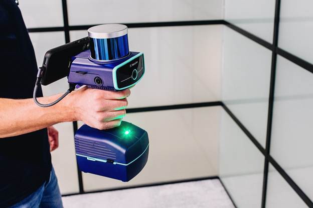
NavLive launches Control Points to deliver higher-accuracy 3D scans and verified site data
Posted On December , 2025
NavLive, the AI-driven 3D scanning company, has launched its new Control Points capability to improve the accuracy and reliability of 3D scans for construction, architecture, and surveying teams.
The feature introduces a faster, integrated way for teams to ground their scans in real-world coordinates, reducing drift and alignment issues that can lead to costly errors or repeated site visits.
Control Points gives users the ability to log survey markers in real-time during a scan and to import external ground-truth coordinates into the NavLive Portal.
Once captured, scans can be aligned with this real-world information through two methods: a simple rigid alignment that positions the entire model without altering the point cloud, or an optimised non-rigid alignment that adjusts the data to ensure both captured and imported coordinates match with higher precision.
This workflow helps eliminate the subtle drift that can accumulate as operators move through large or complex environments, and it allows teams to merge multiple scans into a single, coherent coordinate frame.
The feature also introduces visual verification tools that highlight alignment quality and accuracy, giving teams confidence that the dataset they are using is fully validated.
Powered by NavLive’s AI and multi-sensor reality capture technology, the new capability improves the integrity of 3D models from the moment of capture, reducing post-processing time and strengthening downstream tasks such as planning, BIM coordination, and digital twin creation.
The capability has been developed in close collaboration with architecture, engineering, and surveying specialists who require dependable, real-world accuracy for design, measurement, and compliance workflows.
Integrated directly into the NavLive Portal, it supports professionals working on fast-moving construction programmes, multi-disciplinary design environments, or long-term monitoring projects where verified data is essential.
Chris Davison, CEO of NavLive, said: “Precision is everything in construction and surveying. Even small amounts of drift can undermine decisions later in a project. Control Points allows teams a fast and dependable way to ground every scan to real-world truth, whether they need quick alignment of a single capture or combining multiple datasets.
It brings together the speed of mobile LiDAR with the accuracy of traditional survey methods, giving users data they can trust without slowing their workflow from first capture to final model.”
Business Connect Credits by Asian Connect & Business Connect
